Conventional wisdom regarding Michigan’s congressional redistricting process to this point has looked towards the state Republicans dealing with Michigan’s lost seat by consolidating Sander Levin and Gary Peters into a single district. Two relatively new sources of information are challenging that wisdom.
First, the actual census numbers came out. And the beating that Detroit took over the last ten years was a lot worse than generally thought. As best as I can tell, it’s no longer possible to draw two majority-black congressional districts in Wayne County. Instead, whichever district is centered on western Detroit is going to have to crossover into southern Oakland County to pick up, at the very least, the city of Southfield. Which suggests the option of having that district scoop up as many white Oakland County Democrats as it can, since it’s in the neighborhood anyway. Which in turn suggests that the relevant pairing is going to be Levin-Conyers, not Levin-Peters.
Second, per a recent digest, state representative Marty Knollenbeg, a member of the redistricting committee and son of Peter’s predecessor, has moved from talking about challenging Peters in 2012 to actually starting the machinery of his campaign, in the form of an exploratory committee. That suggest that Knollenberg thinks Peters (or at least the bulk of Peters’ district) is going to be in such a form that it would be amenable to electing a Republican. Which again cuts against the Levin-Peters pairing.
So: If there’s a district for Knollenberg, some other district is still geting cut. Maintaining two VRA black districts requires one of the Detroit districts to cut into Levin’s Twelfth. Putting that together, perhaps the Twelfth is the district to go? What would that look like?
I explore three possible solutions after the jump.
Common Threads
All three of my solutions have six districts that are identical: MI-01, MI-05, MI-09, MI-10, MI-13, and MI-14. The new MI-12, which is now the designation for Dingell’s district, stays more or less in place for all three maps also. Here’s the process by which those six districts were built.
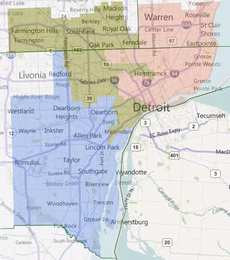
First, the inner Metro Detroit districts. Basically, all three of these maps are looking at scenarios where MI-14, based in western Detroit, takes in the western (Oakland County) portion of the dismantled MI-12, while MI-13, based in eastern Detroit, takes in the eastern (Macomb County) portion of the dismantled MI-12.
The particular version stretches MI-13 to its breaking point — it’s almost literally 50%+1 black by VAP. (It’s 50%+218.) It takes in heavily Democratic Warren, Eastpointe, and Roseville, along with not quite so Democratic St. Clair Shores. (I’m realizing now that I should look at scenarios where St. Clair Shores is in MI-10.) It’s forced into taking the Grosse Points and Harper Woods, and after that it can’t take any more non-black population. That’s why MI-14 has the odd arms to take in white Hamtramck and hispanic southern Detroit.
Besides those arms, MI-14 takes in the rest of Detroit, and then moves north in Oakland County, taking in Southfield for its black population, and the spreading east and west to take in the most Democratic parts of southeastern Oakland. It can’t quite do this cleanly, the little city of Clawson ends up split between it and the undrawn MI-09.
MI-12, having been dismantled, is then reborn as the designation for Dingell’s district. It takes in the most Democratic of the Wayne County suburbs, leaving the western tier of townships for McCotter (or at least he hopes so). Note that dismantling and relocating MI-12 in this way prevents Dingell from hanging on to Ann Arbor, which is going to be problematic for the Republicans later.
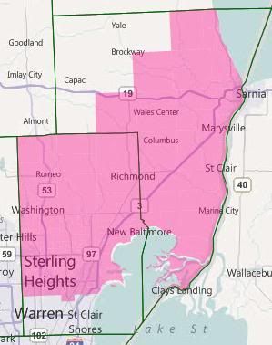
Then MI-10. It takes up the rest of Macomb, and then fills its balance by taking in as much of St. Clair County as it can. There’s been significant population growth in St. Clair and northern Macomb. This, combined with the fact that MI-13 isn’t taking in all of the old MI-12’s portion of Macomb County, causes Candice Miller to lose most of her Thumb Counties.
Obama won Macomb County by about a 36k margin. Warren by itself accounts for about 13k of that margin. The rest of MI-13’s part of Macomb County is about another 15k. That means that the rest of the county went for Obama by about an 8k margin, out of about 285k total votes (for the rest of the county.) Obama won the part of St. Clair County that’s in this district by about 3k out of 72k. That adds up to Obama winning this district by 11k out of 285k total votes. That’s not going to be as comfortable as for Candice Miller as her current R+5 district, but it should be manageable.
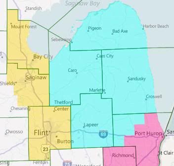
And now the Thumb. The Thumb Counties proper are fairly Republican, so I’m assigning them to our rebuilt MI-09 (which will also be taking in a good part of Oakland, as you’ll see later). That implies the assigned shape for MI-05: Gennessee and Bay Counties plus the most Democratic parts of Saginaw County that will fit.
Which in turn implies this shape for MI-01. Having been kicked out of Bay County by MI-05, it needs to pick up population somewhere, and adding Republican Grand Traverse County to it will help anchor it for Benishek. One goal going forward is to keep that move from harming Dave Camp too much.
Okay, so with those 5-6 district set in place, what sort of options do we have for the others?
Interlude
The current Republican map of Michigan has some very finely wrought pieces. In particular, they went out of their way to make sure that most of Michigan’s Democratic-leaning cities in the outstate ended up in separate districts where they could be drowned out by rural and exurban voters. The cases in point: Muskegon in MI-02, Grand Rapids in MI-03, Kalamazoo in MI-06, Lansing in MI-08. MI-07 was such a case when it was created, keeping Battle Creek safely away from more Democrats (Jackson, so far as I can tell, is swing-tilt-Republican); but Lansing’s western suburbs in Eaton County have blued significantly over the last decade. They then decided that Flint-Saginaw-Bay City was too dangerous to crack, and also packed in Ann Arbor with the southern Detroit suburbs.
This analysis is important because, while we’ve maintained the packed district for Flint, we weren’t able to maintain the Ann Arbor to Dearborn packing. And none of the outstate districts can afford to take on Ann Arbor in addition to the existing Democratic city that they’re warding. The upshot of this is that if Knollenberg is successful at getting a seat made for himself, and if I’m right that Levin’s is then the disappeared seat, then Knollenberg is going to be creating a seat for himself at some other Republican’s expense.
Said another way, the current breakdown of the delegation is nine Republicans and six Democrats. One seat needs to go away; the Republicans obviously want it to be a Democratic one. In addition, Knollenberg is trying to flip a Democratic seat into a Republican one. That would make the delegation 10-4. I submit that it’s impossible to make a map of Michigan with only four districts that are Democratic. 9-5 is the GOP max. Since there are 9 Republicans already, adding another one to the delegation necessarily involves booting an incumbent.
In all three of my sample maps below, that person is Tim Walberg. This is because he is (1) a freshman who is (2) out of step with his swing district which can (3) be made into another MI-05-esque medium-sized-city Dem vote sink. The three options are named for the cities that the new MI-07 covers.
Option 1 — Ann Arbor, Battle Creek, Delta Township
Option 1 has MI-07 cover central Michigan from Ann Arbor to Battle Creek, with an arm reaching out to take in the western suburbs of Lansing.
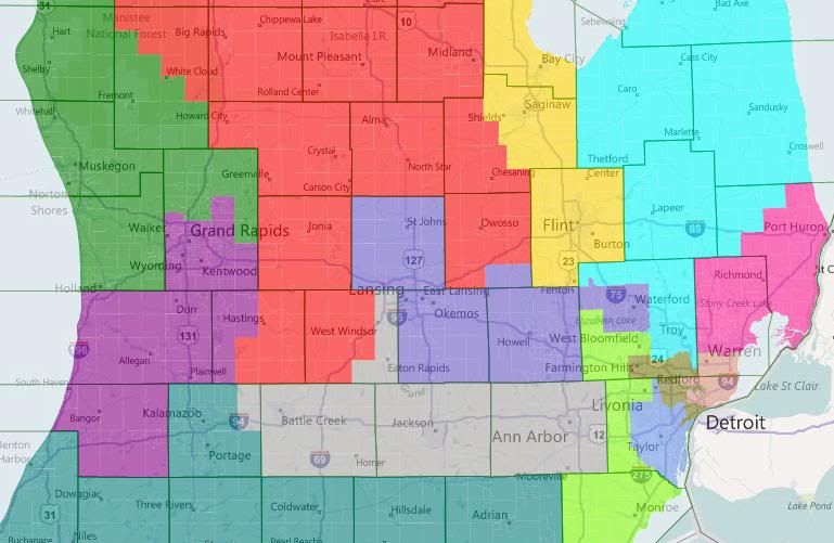
In the west, MI-02 subsumes deep blue Muskegon and the swingy coastal counties with deep red Ottawa and north Kent. (Although not picture, MI-02 takes in all of the coastal counties up to Leelanau. MI-04 has the interior counties that aren’t in MI-01.) MI-03 takes a third of a turn clockwise, dropping Ionia and most of Barry to grab Allegan and Van Buren. Camp’s MI-04 replaces its loss of Republican Grand Traverse with very Republican Ionia and Barry.
Upton’s MI-06 now stretches across southern Michigan, where he picks up an unwelcome constituent in Tim Walberg. Rogers in MI-08 is left to hold down more-or-less the same district that he has now.
Finally, there are the two metro Detroit districts. Knollenberg here adds the northwestern third or so of Oakland County to the Thumb Counties to make the new MI-09, resulting in a reasonably Republican district, even if he’s still holding onto Pontiac. McCotter actually gets shored up here, I think. He picks up Democratic West Bloomfield but loses the most Democratic parts of his current district, which I think balances out in his favor. He also gains Monroe County, which I’m under the impression is swing or lean-Republican these days.
Overall, I think this is the best of the three options for the Republicans. One problem is that having two Oakland-Wayne districts probably violates Michigan’s redistricting standards. That’s more of a political problem than a legal one, though.
Option 2 – Ann Arbor, Battle Creek, Lansing
Option 2 has MI-07 cover central Michigan from Lansing to Jackson, with obviously-gerrymandered-yet-Michigan-standards-compliant arms to pick up Battle Creek and Ann Arbor-Ypsilanti.
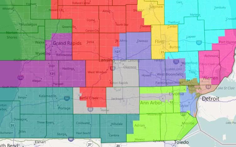
Off-screen, MI-02 has picked up Wexford, Lake, and most of Newaygo Counties from MI-04, which is has in turn picked up the rest of Eaton and a big chunk of Calhoun. This is bad for Dave Camp. In other news worth mentioning, Walberg is now McCotter’s problem — although the massive amounts of Washtenaw he also picks up are an even larger problem. If I recall some math I did the other day, if you exclude Ann Arbor, the rest of Washtenaw voted 2-1 for Obama. Excluding Ypsilanti also helps, but not that much.
Overall, this map is better for Upton, Amash, and Rogers; and worse for Camp and McCotter.
Option 3 – Battle Creek, Kalamazoo, Lansing
Option 3 has MI-07 cover central Michigan from Lansing to Kalamazoo without dealing with the Ann Arbor problem.
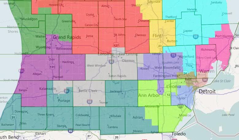
Offscreen, we’re back to the arrangment of the first map — coastal = MI-02, interior = MI-04. Walberg is back to being Upton’s problem — but he’s also lost Kalamazoo, so that’s a legitimately Republican district now. Amash and Camp should both be happy. (Amash’s district in this arrangment, incidentally, is at zero-deviation from ideal.) Rogers should be okay — taking in Ann Arbor for Lansing-East Lansing should balance out. But McCotter’s still in trouble — again, even without Ann Arbor, Washtenaw is a 2-1 Obama jurisdiction.
Bonus Option
As I was writing the diary, I had the inspiration for a pro-Knollenberg, anti-Walberg map that cut out Dingell instead of Levin. MI-13 is 52.2% black VAP, MI-14 is 53.4% black VAP. Here it is without further commentary, because I need to get myself to bed.
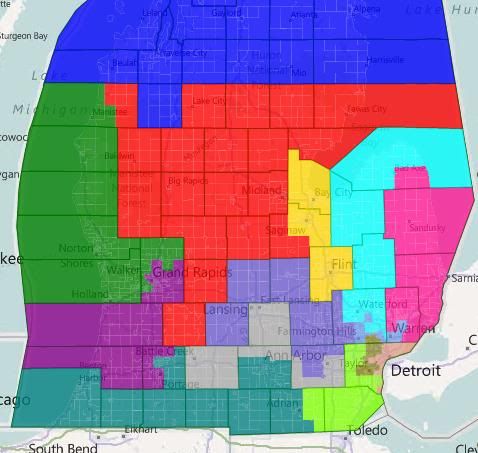
All Washtenaw plus all Ingham plus Jackson city and bits of the north-east of that county.
That leaves Rogers with enough of a margin to pick up Pontiac if he needs to.
My map couldn’t create a Knollenberg district, because I was trying to make the Levin-Peters district work. I got it down to 55% Obama, but only by putting Rogers into a narrowly Obama district and not helping McCotter at all. If he does want a district, I think you’re right the Detroit districts need to cross into Macomb and Oakland respectively. The double-cross can probably be justified for Oakland as one is necessary for VRA purposes, since the redistricting statute carries no legal force.
You could also consider dropping more of Saginaw county plus northern Bay and trying to give Kildee Pontiac too.
Its all based on whether the state surpreme court would allow the double cross from Wayne County to Oakland county for McCotter and Conyers. Conyers certainly has some protection under VRA retrogression rules. I guess we see over 50%AA in both CD1 & CD13? Do we see more AA% then keeping both in Wayne county? To me that would be the crucial question. If you can keep both seats over 50% AA this way and under the both in Wayne county plan they are 50% or under legally this map could fly. Maybe as courts are funny and not predictable. I believe there is substanial AA voters in southern Oakland county and that could be key in this map.
I personally deplore uncertainty in redistricting. If I was the GOP and thought “theres a 10% chance the courts could toss this map”. I would recommend drawing a safer alternative and that would mean no Knollenberg seat. That’s just me. I might add preserving a seat for Levin has its pluses, lots of seniority, but I ditching the Dingell seat.
I think if you shed some of the outer parts of Bay and Saginaw Counties, you could grab Midland as well while still having a plausible-looking district.
Of course, if you want to be really adventurous, just by looking at the populations it seems like a linear Bay City-Saginaw-Genesee County-Lansing district is possible, although it would never make it past the courts.
How about using one of the VRA districts to eat Ann Arbor?
The green district is 50.3% black VAP, the purple one is 57.5%. Also, the only municipality that was split was Taylor, solely for contiguity purposes. This would make life really hard for Dingell, as Romulus, Inkster, Dearborn and Dearborn Heights also get thrown into the VRA districts.
but I though because Detroit lost so much black population that they’d be allowed to just make 1 majority-black district that’s like 57% or so and do what they want with the other.
Great maps overall; I don’t really feel qualified to comment on the Detroit districts, but regarding your first, third and bonus maps, though, I don’t think Upton would survive a primary challenge from Walberg with those kinds of maps. He’s only had serious opposition three times in the Republican primary; once in 1986, when he beat Mark Siljander, who was the incumbent at the time but is also a total nut (and is, as far as I know, heading off to prison). In 2002 former State Senator Dale Shugars ran against Upton on a platform mostly based on abortion (Upton is pro-life, FYI) and got plastered, reminiscent of Levin-Switalski last year, though not quite by as big of a margin. But than Jack Hoogendyk decided to attempt a vigorous teabagging of Upton last year, and only lost 57%-43%. Walberg is similar to Hoogendyk in a lot of ways, but doesn’t have the stench of LOSER on him and has more money/resources to tap into. Upton’s toast in that scenario.
Also, regarding your third map, I’m not sure how feasible it is to split Kalamazoo and Portage into separate districts. They’re basically one city operating under different city charters (they’re even geographically adjacent, like Benton Harbor/St. Joseph), and when Upton retires there’s a lot of ambitious Republicans in Lansing from the Kalamazoo/Van Buren/Berrien areas who would like a shot at his seat, so my guess is those three counties will be together in any redistricting plan.
Would it be considered retrogression to move MI-13 from a majority African American district to a majority-minority, African-American plurality district by including Southwest Detroit (or, to paraphrase from a famous song, Los niños nacidos y criados en el sur de Detroit)?
I would think that Hamtramck should also end up in MI-13, as Clarke’s mother is Bangladeshi, and Hamtramck has a large Bangladeshi community.
I’d also expect Clawson not to be split, but to end up in the Knollenberg district, as it’s a part of his current state house district (along with Troy).
The second part is correct, but if I’m remembering my Census numbers correctly, St. Clair County was one of the few metropolitan counties in Michigan to have actually lost population over the decade. It wasn’t a lot, but it was still a pretty rare loss.
Not sure if this is either here or there, but Detroit’s eastside (east of Woodward) has been losing population faster than the westside, which has been the case since the decline began, I believe.
Lastly, for anyone interested, Detroit black exodus was much greater in Macomb County than in Oakland County. This was the opposite from the 90’s when blacks were migrating to Oakland County, mostly. There is still a significant barrier in Western Wayne and Downriver, so most of the communities changed a bit less or absorbed hispanics which have begun to outflow Southwest Detroit.
A few examples of black outflow in Macomb County:
– While Warren lost a little over 3% of its population over the decade, it went from 90.4% white to 77.1% white, and from 2.7% black to 13.4%.
– Harper Woods, in Wayne County abutting Macomb County and The Pointes, may have had the most dramatic change of all of the communities in Metro Detroit. It went from 84.9 white to 48.5% white (and surprisingly, all of its elected officials are still white, so the change must have literally happened within a few years during the decade), and from 10.2% black to 45.3% black.
– Clinton Township is now nearly 13% black (4.6% in 2000), Eastpointe (East Detroit) is now 29.3% black (4.7% in 2000), Roseville is now 11.7% (2.6% in 2000), Center Line – and enclave within Warren – went from 3% to nearly 12%, etc….
– Just some other changes in random…Hamtramck is now 21.4% Asian and 19.1% black and only 53% white. Fernadale across 8 Mile is now nearly 10% black as if neighboring Hazel Park. Neighoring Oak Park, one of the original black-friendly suburbs, is now officially black majority having gone from about 46% in 2000 to 57% in 2010. Southfield’s now 70% (up from 54%) and neighboring Farmingtown Hills is now 17.3% (up from 6.9%). Back in Wayne County, Redford Township neighboring Detroit went from 8.5% to 28.7% black. Westland 6.7% to 17.1% black. Downriver Ecorse and River Rouge as both now have black pluralities with double-digit hispanic populations. Romulus is coming up on majority black in the coming few years (from about 30% to 43%…
– Asians now make up nearly 16% of Novi, 19% of Troy, and 10.5% of Rochester, nearly 15% of Farmington, 10% of surrounding Farmington Hills, 11% of Northville Township, 14.4% of Canton, and 14.3% of Ann Arbor.
Again, none of this is neither here nor there, but thought you guys may be interested in the changes.
http://www.detnews.com/article…