Maintaining two VRA majority-African-American districts in the metro Detroit area is going to be much more of pain than I originally thought. In the relevant population by CD thread, I breezily commented:
And, on an even more important “not-to-mention” note, the Detroit metro area still has more than enough African Americans for two VRA districts, so consolidating MI-13 and MI-14 isn’t in the cards quite yet.
This is not untrue, but the measures required to get those two districts were a lot more dramatic than I expected. The most recent Census estimates painted a very different picture from the actual Census’s report of massive population loss in Wayne County. And so the new districts are likely to be quite different from what I (and others) had previously imagined.
After the jump, I present two different scenarios for the Detroit area districts. Please feel free to post your own — this is very much more about getting a discussion going than presenting anything close to a polished proposal.
Map 1: Skirting the Line
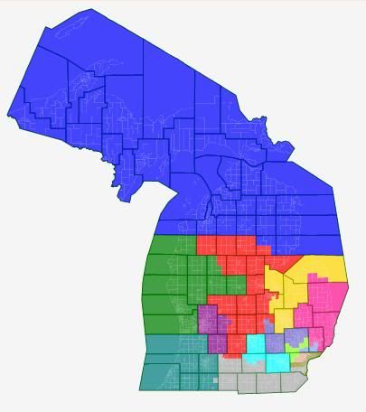
So far as I can tell, this is the best you can do in terms of maximizing the African American percentages of the two Detroit districts while staying in Wayne County. However, the two Detroit districts are majority African American by total population, but not by VAP. So to the best of my understanding of current case law, this solution is VRA-suspect.
Which is unfortunate for the GOP, because this is reasonably successful map for them. Basically, this is an attempt to cut out both Dingell and Peters, while replacing one of their districts with a new safe Ann Arbor plus Lansing district.
District-by-district, briefly:
Benishek’s MI-01 (Blue) is shored up for the Republicans with the addition of Grand Traverse County. Likewise, Upton’s MI-06 (teal) gains Allegan County. Amash’s MI-03 (purple) holds more or less steady, as does Miller’s MI-10 (pink).
Huizenga’s MI-02 (green) – currently the most Republican district – absorbs a couple of problematic counties from Camp’s MI-04 (red). MI-04 is a little shaky for the Republicans, but I’m not sure how to fix that.
Walberg’s MI-07 (grey) loses Eaton and outer Washtenaw County and picks up Monroe County and the southern tier of Wayne County – I could be wrong, but my instincts tells me that’s a wash. Kildee’s MI-05 (yellow) stretches north to take in more of the Thumb and all of Bay County, which marginally weakens it for the Democrats. MI-09 (cyan) is a new heavily Democratic open seat stretching from Ann Arbor to Lansing.
Then, we move into the Detroit Metro area. Massive population loss in Detroit causes Conyer’s MI-14 (brown) and Clarke’s MI-13 (salmon) to chew up most of the Wayne County portions of Dingell’s dismantled MI-15. They’re 50.6% African American total pop, 49.6% VAP and 50.3% African American total pop, 49.5% VAP respectively. Levin’s MI-12 (cornflower blue) stays more or less the same, picking up the rest of Royal Oak from Peter’s dismantled version of MI-09.
Speaking of which, that’s been bisected between McCotter’s MI-11 (lime) and Rogers’s MI-08 (slate blue). McCotter picks up Peters himself and some of the more Republican parts of the dismantled Ninth. Rogers gets some of the most Democratic parts of the old ninth in West Bloomfield, Pontiac, and Auburn Hills — but he no longer has to worry about Lansing, so he should still be fine.
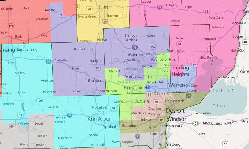
Map 2: The Problem of Pontiac
Same thing, just zoomed in with locality lines
This one really just focuses on the two Detroit districts. In contrast to the first map, you’re looking at two true majority African-American districts. MI-13 (salmon) is 53.0% African American on both measures. MI-14 (brown) is 56.5% African American by total population, 54.6% African American by VAP.
So far as I can tell, stretching Conyers’s district over into Oakland County like this to pick up Southfield and Oak Park is the only way to get the two Detroit districts to combine into majority-African-American status. Having done that, stretching up to majority-African-American Pontiac seems to make a lot of sense.
Having Clarke’s district stretch through Dingell’s Dearborn to get to majority-African-American Inkster isn’t strictly necessary to get to 50% African American by VAP, but it does help.
Now, if I’m right in my understanding of case law and this basic configuration is necessary to comply with the requirements of the VRA, then state GOP has a problem on its hands. They can’t draw a district for McCotter that (1) he can win and (2) conforms with state redistricting standards.
Michigan state redistricting standards frown on county and locality splitting and are generally understood to prohibit what user rdelbov generally calls a “double-cross” — that is, having Districts X and Y share both Counties A and B. If you look over the current map, you’ll see that interpretation seems to have been followed under the last GOP gerrymander. McCotter’s district is the one allocated Oakland-Wayne split district. If Conyers’s district becomes one, then McCotter’s district, under state redistricting standards, can’t do that any more. But McCotter lives in Wayne County, and he needs those Oakland County Republicans to have a winnnable district.
Now, the potential out here is that, so far as I understand it, the state Supreme Court basically declared the state redistricting standards non-justiciable the last time a suit was filed based on them after the 2000 round of redistricting. So if the GOP wants to ignore them, they probably can.
I drew in sample districts around the two Detroit districts. The Detroit metro area ones more of less work, from a GOP perspective, although some of the non-pictured outstate ones were pretty ugly. But without knowing how to resolve the “double-cross” conundrum, I wasn’t really sure how to proceed.
Wrap-Up
So, which is the better way for the GOP to push the limits of redistricing law? Two only-borderline majority African American districts in Detroit? Or violate (potentially unenforceable) state law and have two districts cross the Oakland-Wayne border? Or do you have a better solution altogether?
minority-majority (i.e., black + hispanic) they are probably OK under the VRA. I don’t think this exact situation has yet arisen, though.
I drew both Detroit districts crossing 8 Mile, with Conyers’ district looking much like your second map (but with Inkster) and Clarke’s picking up Warren. On the state map, Benzie, Leelanau, and Grand Traverse are in MI4 and everything else off the map is in MI1.
I let Camp keep his current district basically intact. I don’t think they would strengthen Benishek at his expense. I gave Dingell basically his old downriver district which I renumbered 12. Like you, I drew a “Joe College” blue sink from Washtenaw to Ingham. McCotter’s district ends up about the same. My MI9 (where Levin lives, but Peters doesn’t) is likely more red now with Lapeer, Port Huron, and some of northern Oakland. MI6 is strange, going almost to Lake Erie, but I think Upton could still win it.
I like your original map the best. Walberg might struggle a bit but I like it from a GOP standpoint.
I have also seen the over Sagninaw and East to the Thumb for Camp here in earlier maps. I like that variation as well. 8 mile road is such a barrier, for the races, there are not a lot of AA’s in MacComb county so the move of CD1 or CD13 in there does not seem to work.
The VRA always overrides state law (and even more so state ‘tradition’) whenever necessary in order to meet the requirements of the federal law. Were that not the case then the VRA would be meaningless, because states that did not want to comply would always be able to draft state provisions to contravene the VRA provisions.
14th (olive): 49.8% white, 42.8% black
13th (salmon): 49.6% white, 41.3% black
12th (cornflower blue): 35.1% white, 53.7% black, 6.6% hispanic
Almost certainly illegal, but possible.