This diary presents two different flavors of Ohio maps: Fair Districts (a la Florida) and GOP-Friendly. Ohio doesn’t have partisan data in the App, so these maps represent my best guesses. I definitely consider these maps to be more discussion-starters about maps under the newly-released 2010 data than polished proposals. In the comments, please feel free to share your own maps or information about local partisan leanings that needs to be taken into account.
Fair Districts
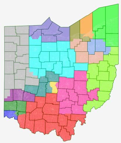
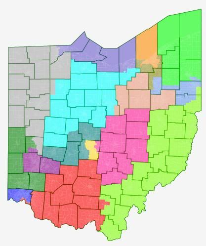
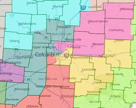
Ohio’s geography doesn’t lend itself to “must draw” fair-districts as much as Florida’s does, but I think this is a pretty good stab at it. All three of the counties big enough to support a single district have them, and the rest of the districts are reasonably compact. There are 13 counties statewide split between two or more districts. Columbus is the only incorporated locality split between districts. This is mostly because Columbus has some bizarrely intricate boundaries that are hard to follow. I ended up using the Scioto River as my boundary guide instead of city limits.
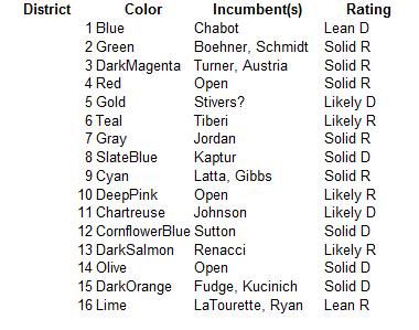
If my ratings are to be trusted (and they probably aren’t), this would be a 9 R – 7 D map. VRA note: OH-15 is a plurality African American district, 47.0% VAP.
GOP Friendly
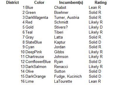
I used the first map as a base, which is probably not the best idea. But I like good-government maps, and I wanted to try to find a GOP map that conformed at least somewhat to good-government principles. All changes described are relative to the Fair Districts map above.
The basic idea here is to pair up Turner and Austria in a Dayton-based district and to pair up Fudge and Kucinich in a Cleveland-based district. Columbus also gets a Democratic vote sink, which means that this map calls for the Republicans to take the hit on both seats. That might not sound “GOP-Friendly”, but they’re maxed out in Ohio post-2010. I think 11-5 is not a bad target for them.
So what’s changed?
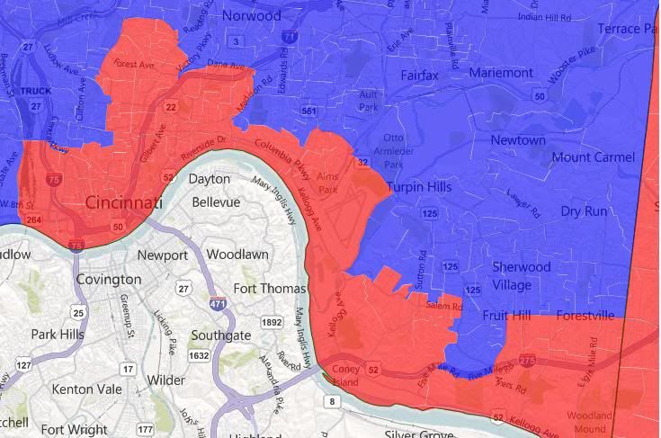
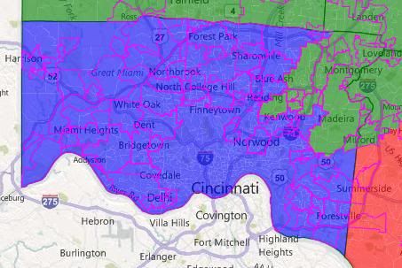
First, Cincinnati. Hamilton County is about 80k too many people for a district. In my Fair Districts map, that 80k were suburban whites added to Boehner’s district. In my GOP-Friendly map, that 80k is a plurality-African-American strip along the Ohio River, mainly in downtown Cincinnati, added to Schmidt’s district. Schmidt might not be able to carry a district that incorporates that part of Hamilton. But most Republicans should be able to, so I think worst case scenario is that they lose that district for a cycle. I’ve also wrapped Boehner’s district around Dayton again, so that he has more of his current constituents.
Second, the northwest. Kaptur’s (under this map) OH-08 has been stretched eastwards, pulling OH-07 and OH-09 north. OH-07 and OH-09 have also swapped some territory. I’m pretty sure under the Fair Districts maps the district that Latta lives in has more of Jordan’s old constituents and vice versa. I tried to rectify that here.
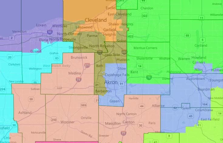
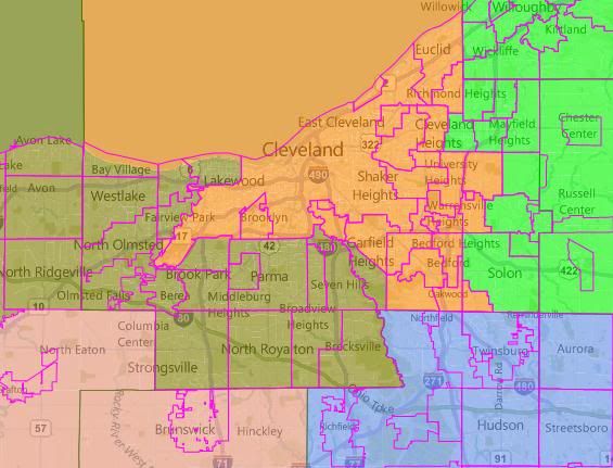
Third, the northeast. There are some major changes here. OH-08 and OH-09 have subsumed Lorain County. This has push OH-14 south and east, where it picks up all of Cuyahoga outside of OH-15 and plunges down into Summitt County and (re)gains Sutton as its incumbent. OH-12 becomes a dumbbell-shaped district linking Akron and Youngstown. It does some swapping with the neighboring OH 16 and OH 11 to get incumbents’ residences right. OH-13 drops out of Lorain and picks up Ashland, shoring it up relative to the Fair Districts map. I would be worried as a Republican about LaTourette, because without partisan data, I’m not sure were he stands in that district.
Fourth, the southwest. Johnson’s district drops Youngstown, to his relief. It stretches south into OH-04 (which went into Cincinnati). It still needs to grow though, so it pushes OH-10 north. This is convenient, because OH-10 needed to come north so that Gibbs would live in it. (I think he lives in Holmes County, but I’m not sure.)
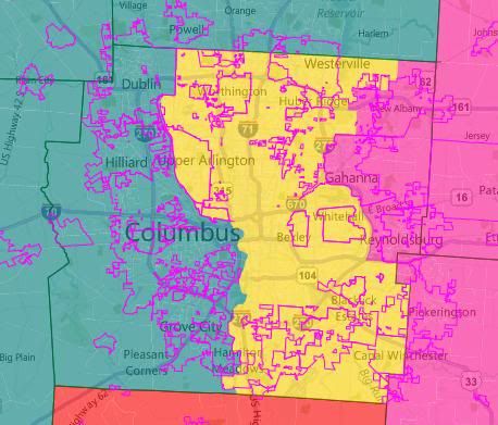
Lastly, Columbus. This probably ought to change, since if the Republicans do create a Democratic vote sink here, they’ll want it to be the best one possible. But without partisan data by precinct, I have no idea what that looks like. If the Republicans aren’t willing to concede a distrct in Columbus (which seems likely, if foolhardy), I think they should probably look at splitting Franklin four ways. Again, without partisan data (and without knowing where exactly Stivers lives), it’s hard to say what that should look like. But here’s a possibility:
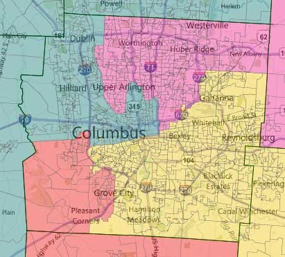
Has there been any serious talk in Ohio about creating a Columbus vote sink? I’ve seen it mentioned here at SSP a number of times, and a few maps at RRH did it, but I haven’t actually seen a news source about redistricting mention Republicans thinking about doing so. Also, does anyone know where in Cincinnati Chabot lives?
I think Schmidt would be toast in your 4th district in the 2nd map. Combine downtown Cincinnati with even more conservative-but-traditionally Democratic Appalachian territory in the southeast and it seems like it’d be impossible for her to survive another 2006 or 2008.
I doubt the GOP does the Franklin county sinkhole. I would look for a similar split as in the 2001 map.
minority population in either Hamilton or Franklin county to require a seat under Section II VRA. You can’t get to 50% of VAP in either county. You can barely get to 50% in Cuyahoga county but you will see that seat protected by the GOP.
In your 2nd map, your OH-14 is actually a swing district I think. A lot of the communities in outer Cuyahoga and northern Summit counties are actually quite republican. Cities like Westlake, North Royalton, Strongsville, Hudson, and Solon are usually republican-leaning. They get balanced out by places like Parma, Berea, Lakewood, Barberton, and Copley. It’d probably still be slightly D+PVI, but easily winnable for the R’s in a year like 1994 or 2010.
On the same token, I think Steven LaTourette would be toast in your 2nd map. His district is only R+3 as it stands, and you made him take on a LOT of democratic territory in Portage & Trumbull Counties. Liberal bastions like Kent and Warren, currently in OH-17, got moved into your OH-16.
The rest of your 2nd map makes a lot of sense. Your district for Jean Schmidt seems relatively republican leaning, but it’s definitely weaker than before. Given her weakness as a candidate she could definitely go down in a district that includes Cincinnati plus the more democratic-leaning counties in the south-central corridor like Pike, Scioto, and Ross (all of which went for Strickland and Obama barely lost).
I really like the first map a lot, especially the districts around Cleveland, Columbus, and Toledo. I actually don’t think it’s that outlandish to think the Republicans would eliminate Schmidt by putting her in the same district as Boehner. The thing is, if they do that, it means that they’ll either have to give up 2 of their incumbents and set up a new unoccupied district in the south-central part of the state, or they’ll have to try to cut Columbus into 4. (Yeah, good luck with that)
Of course the real map is going to be a Republican gerrymander, and I really hope it backfires.
Both are pretty generic Republicans who have overperformed in their districts and never caused any drama. If the local GOP is smart, they will reward politicians who fit that description:
Tiberi (Obama district)
LaTourette (never breaks a sweat in swing seat)
Turner (ditto)
Austria (strong ties to Legislature, overperforms baseline in his district)
Latta (probably the most vulnerable of these, if only because his district is so easy to carve up)
After that, you have a few other untouchables:
Boehner (duh)
Jordan (chairman of RSC)
Chabot (geographically impossible to remove)
That leaves you with a quartet of freshmen, all of whom have built cases to stay:
Stivers (overperforms in blue district, former state Senator)
Gibbs (strong ties to state Legislature, blew out incumbent by 20 points)
Renacci (strong fundraiser, beat very tough Democrat)
Johnson (district is hard to carve up, but he could very well be combined with Gibbs)
And, the obvious one to go:
Jean Schmidt. Controversy creator and serial underperformer, even in 2010. You can give parts of her very red district to any combination of Boehner, Turner, Austria, Chabot, and Johnson, and the latter two could use the help. The only way I see Schmidt getting a district is if someone else (Turner? Latta? Austria?) runs for Senate.
I am hoping the Ohio holier than thou GOP legislature goes for a complete gerrymander and in the process spreads their votes so thin that Dems win some of their new creations. Splitting up Franklin County four or five ways is insane, but expect anything. Tossing Kucinich in with Fudge and Sutton in with Ryan to create a new solidly Democratic seat in Franklin County is probably a GOP option, but in the end I doubt it happens. It will be really interesting to see what kind of gerrymandering the GOP comes up with. It wouldn’t shock me to see Marcy Kaptur somehow thrown in with Sutton and Ryan. The Republicans will get very, very creative here. I just hope all of the Republican legislatures do what the Indiana GOP did in 1980 and go for an 8 and 1 house delegation only to come back with a 7 and 2 Dem delegation after the 1982 election.