This time, we’ve got an internet application to play with.
The task of dividing Missouri into 8 districts with the population estimates is still a nightmare.
When it comes down to it, the best possible deal for an 8 district map is a 4/4 delegation split. Best possible, without a gerrymander. Currently the delegation is 5 Republicans/4 Democrats.
With all the momentum of under two hours of work, here’s an attempt to split the state into 8 districts with a 4/4 split.
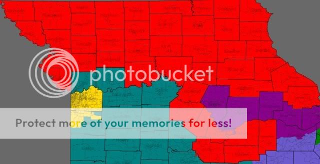
First, the STL districts.

The 1st district (Blue): 738926 people, 45% white, 49% African-American
The 2nd district (Green): 738908 people
The 1st district walks a balance between helping the 2nd, and also keeping the legislators in that area happy enough to actually approve such a map. The 1st moves west into Maryland Heights and south in the city of St. Louis. Ideally, the district would still go 2 to 1 for Democrats, at the very least. A drop from 3 to 1, but still a good solid district. Here’s a before/after of the lines. Most of the tracts moving from the 1st to 2nd were coincidences from the tractpoking that was done to form the district.
The 2nd district includes the homes of Todd Akin and Russ Carnahan. The district also includes a chunk of Akin’s STL county district (except for Chesterfield). As well, a part of Jefferson County, and Russ’ South County district are in the district unsplit. Ideally the district would be 50/50.
As for the third district (pop. 738910)

Officially, this district is open. It combines Boone County, one of the emerging Democratic votegetting counties, with the rapidly blueing St. Charles county. Along with the I70 corridor and some other counties in the area.
Cole County is split with Jeff City in the 3rd and the rest of the county in the new 4th district. Franklin County’s split puts the northern part of the county in the 3rd and the southern in the 8th.
As for the 4th district.. it’s a sign of the ridiculous nature of the 4th that you can’t fit it into an image on the minimum zoom.
Yes, really. The realities of the corridor district kind of makes this district ridiculous. As well, Sam Graves and Blaine Luetkemeyer both live in this district. The population in the new 4th is 738858. The only split in it not already covered is two tracts in Camden County near Osage Beach (which are in the 9th district, instead of the 4th). Unfortunately for candidates, this district is huge, covers multiple TV markets. As well, we can only break it down by region. Buchanan and Platte should be Dem friendly, the Northwest Corner is more Republican, North Central Missouri is a fusion of co-ops and Republican voting, the Northeast corner of Missouri could be a good Dem area. The Northeast part of the district between Kirksville and Moberly could also produce a good showing for Dems. But a lot of this depends on who the candidates are, and if they’re great at exhaustive campaigning. 44 counties in one Congressional district might be a record for this state.
The 5th district (pop. 739048) is slightly more compact.

The temptation to put some of the Republican parts of Jackson County somewhere else is still there. But when the county is 60/40 blue, then it’s not a huge pain to have to put up with parts of EJC, or with Cass County. Cass County kind of got cut up in the quest to get within 100 of the ideal district population.
As for the 6th district (pop. 738852), it’ll be more competitive when it’s opened up by retirement. But it’s a challenge.

The district obviously adds Clay County. It loses a sliver of Jackson County, along with Webster County and parts of Cass County. The district also gains ground in Polk, Camden and Phelps Counties. Ideally, the combination of traditionally Democratic areas in West Central Missouri and Clay County could outmuscle the traditionally Republican lean of the rest of the district.
My apologies to Phelps Countians for the splitting of their county.
The 4th and 6th could switch numbers on this map so that Ike Skelton is the incumbent in the 4th, Sam Graves is the incumbent in the 6th, and they won’t have to order cards with new district numbers on them.
As for the 7th (pop. 738989).. it is what you think it is

It picks up the rest of Taney County, Webster County, a tract in Wright county, and Ozark County. It loses part of Polk County. It’s still very Republican.
How about the 8th district (pop. 739114)?

The eighth loses it’s portion of Taney County, loses part of Phelps and Wright counties, loses Ozark County. It picks up Southern Franklin and Southern Jefferson Counties, along with Crawford and Ste. Genevieve counties. As to how the 8th splits when a non-Emerson is on the ballot, i’m not particularly sure. But when the two biggest counties in the 8th are strong Republican (Cape and Butler), then that’s a lot of votes to start with.
When it comes to redistricting, barring a great compromise, the map will be drawn or approved by a panel of Federal Judges. But the Republican plan will be closer to 6/2 if they act as how they usually act. They’ll keep the 4th as is and wait. They’ll put Southern Clay County in the 5th. They’ll stack Democrats in the 1st. Russ Carnahan’s house will end up in a Republican 2nd or the 8th.
Basically.. redistricting will be very unpleasant this year unless something unexpected occurs.
But until we get the real numbers, we’re left to mess with an online application in an attempt to see how many counties can fit into one Congressional district. When the real numbers come out, then the computers hidden in the basement of the Capital will be put to work with all the electoral and socioeconomic stats to form the ‘perfect map’
Which will then be exposed within several cycles.
But it’s raining in the KC area. So why not have a diversion for a bit?
in MO’s future. The litigation over the instructions given to the special master will really be something. . .
These are much more compact lines than my map.
I love this application. I’m having trouble figuring out how to access saved maps or paste the images though. IN any case, some of the features of my map:
Dist. 1. I have a similar 1st district except my district shifts towards taking in all but a few of the southwestern precincts of St. Louis City and adds a few precincts from the tail of St. Charles County on the border of Illinois. My district, too is plurality African-American
Dist 2. My district is very different. I noticed that Todd Akin’s portion of St. Louis County voted fairly heavily for John McCain while his portion of St. Charles County was fairly evenly split. Thus, I only added the western inner-suburban of Akin’s St. Louis County census tracts to the seat. I include nearly all of Carnahan’s St. Louis County precincts, the remainder of St. Louis City and stretch into St. Charles County to take in nearly all of the precincts that had been in Akin’s district (except for far eastern and western St. Charles). I then snake the district up the Mississippi river to take in some Democratic-leaning tracts in Pike County.
Dist.3 Inspired by your district, mine takes in Columbia County and Jefferson city, Calloway, southern Montgomery and Warren counties. But instead of going to St. Charles, the district veers south and consumes GOP-leaning Crawford County but then takes in Democratic-leaning counties, including: all of Jefferson, Ste. Geneveive, St. Francois, Washington, Crawford, Iron, Reynolds and Shannon (as well as GOP Dent county). I think that this district is probably fairly even on the Presidential level. However, Democrats have shown quite a bit of local and congressional-level strength in these counties. The district would not have an incumbent and I believe a Dem would be favored in an open seat.
Dist. 4 My GOP stronghold. Taking in GOP areas of western St. Louis County, St. Charles, Franklin and Pike counties as well as a few in northern Montgomery and Warren, the district takes in everything north of the following counties: Autrain, Randolph, Macon, parts of Linn (with some possibly Dem areas in SE Linn excluded), Carroll, Caldwell, Dekalb and Andrew. Additinally, a tail drops south of Howard to grab Cooper, Morgan, Monteau, and Pettis Counties. I think this district is brilliantly gerrymandered and it doesnt actually look all that bad.
Dist. 5 Includes nearly all of Jackson County excluding the eastern 2-3 layers of census tracts. It grabs precincts from Southeastern Clay county and also includes about 8-10 northeastern tracts of Cass County. Black population: Approx 155,000.
Dist. 6 My favorite. I believe I have drawn it so that it would actually have been won by Obama. It is a great district for Skelton but I think it would also be good for any Dem. The district includes: Buchanan, Platte, Clinton, Ray, most of Clay (except that in dist. 5), the remainder of Jackson County, Lafayette, Saline, Charlton, a few tracts in SE Linn County, Johnson, Henry, Benton, St. Clair, Hickory, Dallas–and, the stroke of genious–a tail that reaches into Greene county to pick up only the central portions of Springfield.
Dist. 7 A strongly GOP L-shaped district, reaching from Douglas and Ozark to the Oklahoma/Kansas border. It includes the remainder of suburban/exurban/rural Greene county, Polk, everything south of Cedar and reaches north to grab all of Bates and the vast majority of Cass county.
Dist. 8 Not a pretty district but reasonable imo. Includes Southeast Missouri as far north as Carter, Wayne, Madison and Perry. Reaches through Oregon and Howell Counties and north into Texas County to include a block of GOP turf in central MO including: Webster, Wright, Pulaski, Phelps, Camden, Laclede, Miller, Maries, Osage, Gasconade, and the non-Jefferson City majority of Cole county.
All in all, a bold and absolutely unfathomable Dem gerrymander creating 2 solid Democratic districts (1 & 5), 1 leaning democratic (2), 2 toss-ups that probably lean dem as well (3 & 6), and three GOP bastions: (4, 7 & 8).